
Salt Lake City Department of Public Utilities Q&A: Reaping the Benefits of Digitized Permitting and Asset Management
Tammy Wambeam, GIS/IT Administrator for Salt Lake City Department of Public Utilities, spoke with Trimble about her organization’s use of Trimble and Esri solutions to improve collaboration and efficiency.

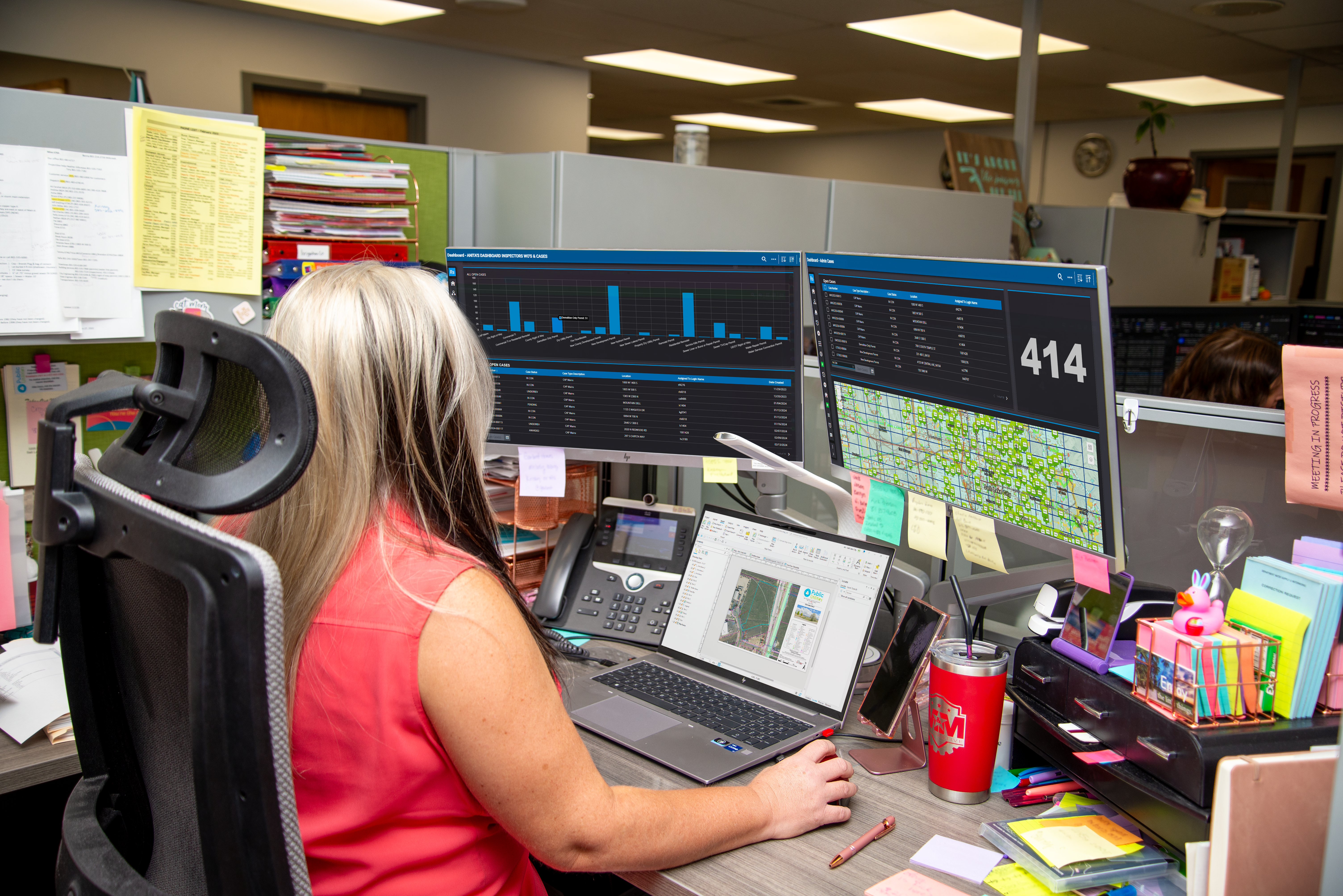
SLCDPU field crews leverage Trimble and Esri ArcGIS to manage infrastructure in downtown Salt Lake City, Utah.
Q: What does Salt Lake City Public Utilities do?
A: Salt Lake City Department of Public Utilities (SLCDPU) provides essential services for Salt Lake City and surrounding areas. We are responsible for operating and maintaining critical infrastructure such as water, sewer, stormwater, street lighting and our watershed. Additionally, we manage permitting activities related to utilities for our community, including inspections, planning, community development, capital improvement projects and more. Our mission is to deliver safe and efficient services to our community and support sustainable growth and development.
Q: What are some unique aspects and challenges of your service area?
A: In total, we manage and maintain a vast network of infrastructure, including 1,324 miles of water distribution, 679 miles of sewage and 360 miles of stormwater infrastructure. Our service area is situated in a very mountainous and hilly region, presenting significant challenges for distribution management and maintenance. With 52 pressure zones across the valley, SLCDPU operates one of the most complex water systems in the Western U.S., primarily due to the elevation changes.
Additionally, Utah is the second driest state in the U.S. We rely heavily on watersheds and spring runoff for our water supply, making water conservation a top priority for our organization.
Q: What were some of the key challenges your organization was facing?
A: Salt Lake City is one of the fastest-growing cities in the Western U.S., and much of our water and sewer infrastructure, such as sewer laterals, are aging and occasionally failing. The combination of rapid growth, aging infrastructure and drought placed increased pressure on us as an organization to operate and maintain our systems efficiently while providing dependable services to the community.
One of our primary goals was to streamline and modernize our permitting process to ensure we are providing efficient services to our contractors and residents. Our previous permitting workflows were largely paper-based or were in different software programs, leading to data being stored in multiple locations and formats. This resulted in inefficient data management, communication silos and duplicate work.
Tracking projects and managing schedules was also challenging. Identifying the responsible inspector or engineer for specific projects was difficult, and we often lacked clarity on the project phases. This led to time wasted in sifting through documents or making numerous phone calls to find project information.
Q: What technology does SLCDPU use to overcome those challenges and improve the level of service to the community?
A: We have been using Trimble Cityworks AMS as our GIS-centric enterprise asset management system since 1998. [Product note: Trimble Cityworks is one of the solutions that powers Trimble's new and improved enterprise asset management capability called Trimble Unity Maintain.]
We recently implemented Trimble Cityworks Permitting, Licensing and Land [now known as Trimble Unity Permit] to centralize our data and improve our permitting workflows.
Additionally, we use Trimble Cityworks Storeroom for our material management, Trimble Cityworks Public Access for customer engagement, and of course, Esri solutions have been a foundational part of our organization, such as Esri ArcGIS for GIS and spatial analysis, along with a variety of other tools like ArcGIS Utility Network, ArcGIS Field Maps and ArcGIS Survey123.
Q: What role does GIS play in the work you do?
A: SLCDPU is a GIS-centric organization, with Esri solutions at the core of our operations Since 1989, we’ve used Esri to visualize historical work order data dating back to the 1970s, alongside general infrastructure mapping based on records from as early as the late 1800s. Having all this information digitized and put into GIS allows us to gain a comprehensive understanding of our public assets, providing data-driven insights that shape our operations and maintenance activities.
Currently, we use Esri ArcGIS as an authoritative system of record for our entire public infrastructure network. Our use of GIS allows us to visualize and track our assets, monitor work activities, oversee ongoing operations and access historical data. The seamless integration between GIS and Trimble has significantly increased our efficiency, enhanced our visibility of work activities and streamlined our asset management and permitting workflows.
Q: How has your long history of using Trimble technology been beneficial to managing your GIS system?
A: One of the main reasons that SLCDPU’s GIS system is so successful is in large part due to our use of Trimble Geospatial hardware and software solutions. For decades, our survey team has leveraged Trimble Total Stations (Trimble S6) and is currently using our Utah Turn Network GNSS system—along with Trimble TSC7, Trimble TSC5, Trimble R780, Trimble R8 and Trimble Business Center to capture and analyze field data.

Access to accurate surveying and mapping data, combined with enterprise asset management and permitting data pulled from a variety of Trimble solutions, has been instrumental in developing and refining our GIS system. Each piece of technology seamlessly integrates and informs the others, creating a cohesive and reliable system of record.
Q: What was the impetus for adopting Trimble permitting software, and how is that solution being used?
A: Before implementing the solution that is now named Trimble Unity Permit, our work order data was separate from our permitting data, leading to fragmented information across multiple systems and paper trails, resulting in data silos and communication gaps. This disjointed process made it difficult to track permitting workflows and oversee projects from start to finish. We realized that we needed a permitting solution that could centralize all of our data and seamlessly bring together the Trimble and Esri solutions that we were already using.
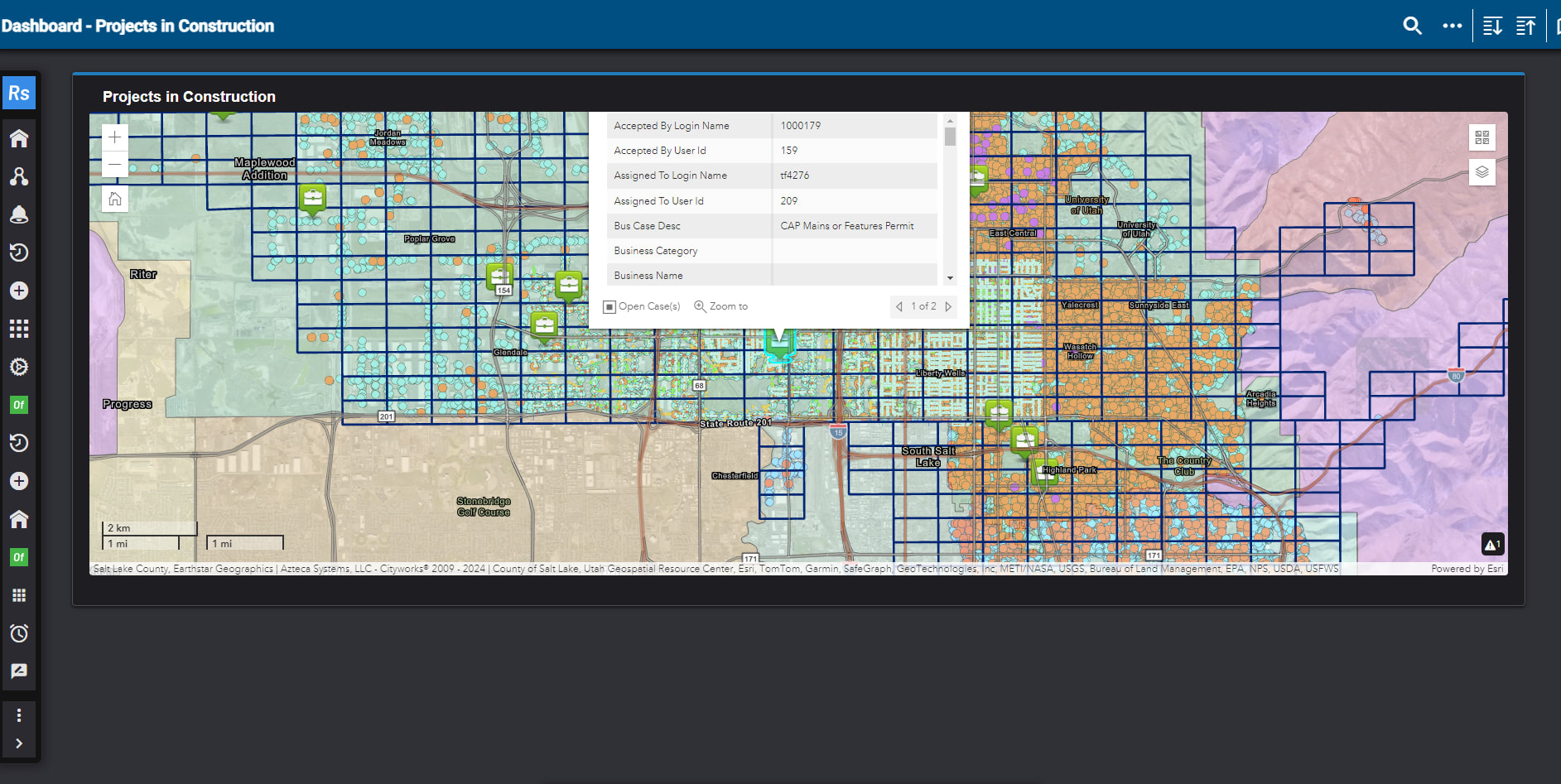
With the adoption of Trimble’s permitting solution, we are able to completely digitize and streamline our permitting, licensing, inspection and plan review processes. We use the Trimble solution in conjunction with Esri ArcGIS to manage permitting activities for utility construction related to new developments, site development, subdivisions, new residences, residential remodels, demolitions, fire flows, dry utilities, and more. Additionally, we track capital improvement projects and infrastructure permitting activities, such as installing new water services, water service repairs, maintaining and constructing sewer lines and laterals, repairing sewer bursts and managing right-of-way permits.
Trimble’s permitting solution—specifically its Trimble Cityworks Public Access component—is used for public-facing permitting activities. Our online public portal allows residents and contractors to easily fill out applications, check the status of pending projects and submit important documents. It has become a key communication piece for us and allows our community to complete their permitting and licensing needs in a user-friendly online location.
Additionally, the solution now called Trimble Unity Permit is being leveraged for reporting and regulatory compliance, helping us ensure that the services we provide are safe and sustainable and meet government regulations for water quality and FOG (fats, oils and grease), EPA regulations for lead and copper, and FEMA reporting. It also aids us with budget tracking and financial reporting, supporting our planning for future projects and maintenance activities.
Q: What are some of the main benefits SLCDPU has seen from its use of Esri ArcGIS and Trimble solutions?
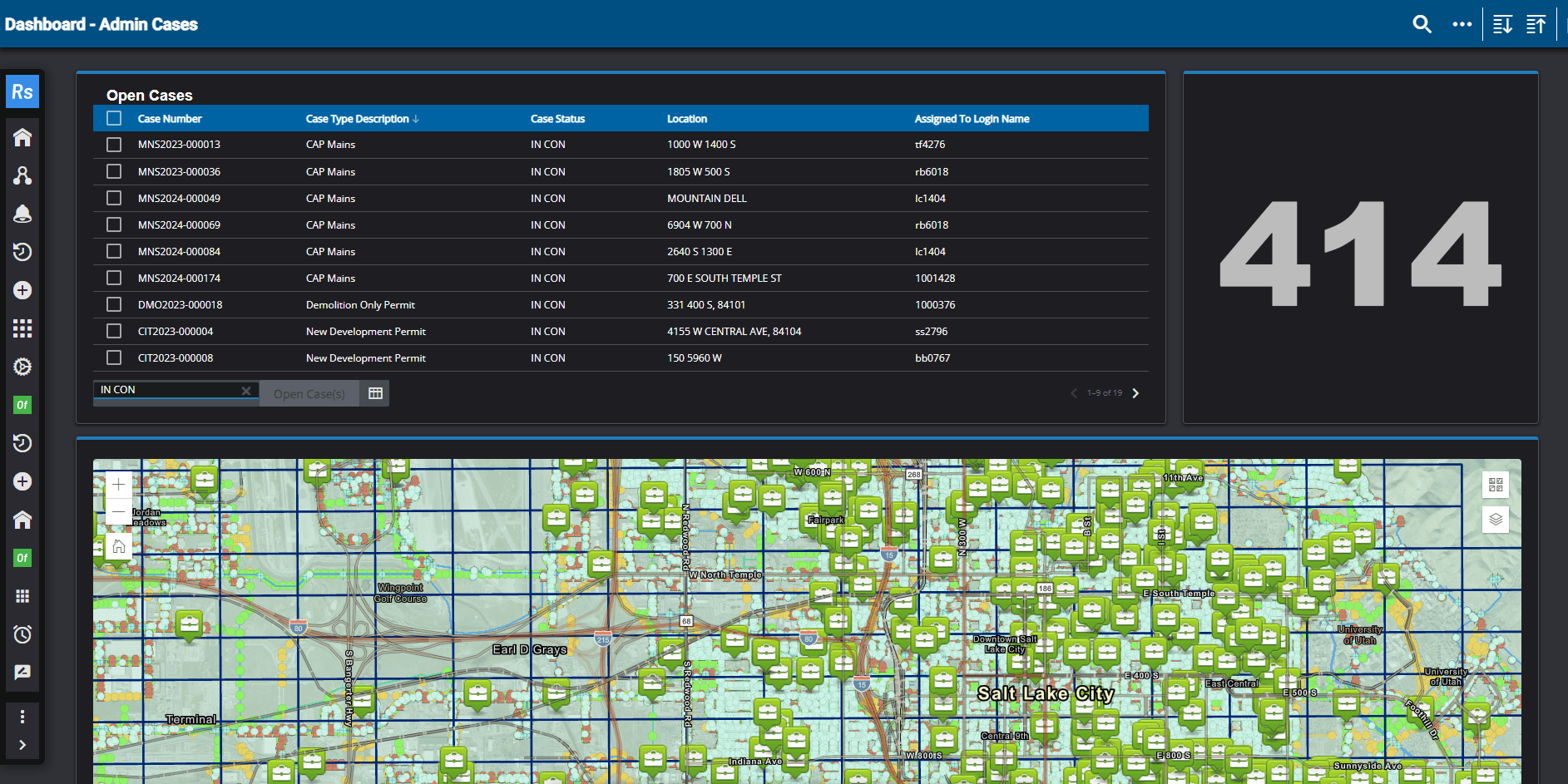
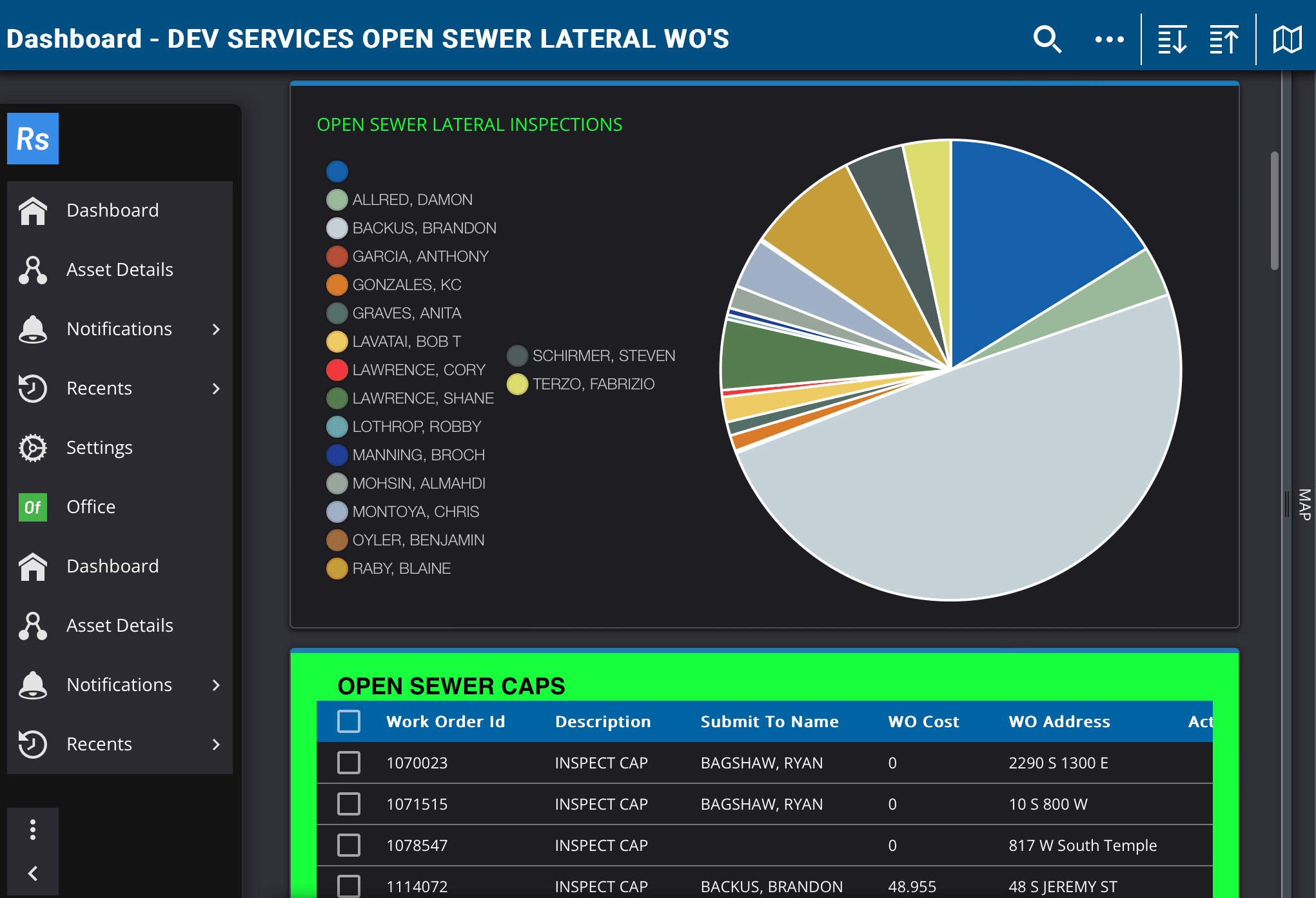
A: SLCDPU’s use of Trimble solutions and Esri ArcGIS has significantly enhanced departmental visibility and communication, allowing us to monitor the progress of work activities, identify inefficiencies and understand the full scope of projects. By consolidating previously siloed permitting and asset management data and workflows into one cohesive system of record, our organizational efficiency has greatly improved. We can now easily access permitting, inspection, work orders, GIS and project data without having to work out of separate systems. Additionally, all of our public assets and permits are now in a searchable format and specific case information such as photos, comments and related files can be attached by our field crews.
Another key benefit is the configurability of Trimble technology. We have created customized templates and have been streamlining workflows through automation. For example, selecting a meter size automatically generates a corresponding work order. Similarly, indicating a water main triggers an automatic inspection and survey that is attached directly to that case. Since our initial implementation of Trimble permitting software in November 2023, our development services team has created over 1,700 cases that span a variety of types. Leveraging Trimble and Esri ArcGIS enables us to create an end-to-end connected data environment, from the initial permitting and construction process through ongoing operations and maintenance.
We have also been able to improve efficiency and increase transparency through our use of dynamic dashboards and interactive GIS maps that can be easily shared. This data visualization capability helps us balance workload distribution, inform scheduling and make hiring decisions. SLCDPU now has the tools necessary to perform a more comprehensive data analysis that will help boost our productivity and further streamline our workflows.
Q: What are some future goals for SLCDPU?
A: We want to leverage Trimble solutions to establish a more data-informed baseline for the cost of inspecting new water mains, ensuring that we are charging an appropriate amount.
Currently, we are conducting impact fee and rate studies to understand how much our customers are paying for inspections and plan to reorganize our inspection fee structure to be more equitable. Additionally, we are trying to increase our team’s efficiency by tracking workflow metrics like where most of our time is spent and where there is room for improvement.
Q: What advice would you give to other organizations who are going through their own digital transformation?
A: One key piece of advice is to engage stakeholders who are excited about the digital transformation. Initially, keep your core team of stakeholders small—about five people—to avoid becoming overwhelmed. Once you have a basic workflow established, gradually involve more people. This phased approach helps manage the implementation process more effectively.
Having an experienced consultant can make a significant difference. We benefited greatly from a Trimble consultant who guided us through the complexities of creating tasks and organizing workflows. Their experience was invaluable—they were able to provide insights on best practices from other organizations facing similar challenges.
It's also crucial to be transparent and open throughout the digital transformation. Show your team the entire workflow from start to finish, so they understand the context of their specific tasks. This helps them see the big picture and appreciate the amount of work involved. Demonstrating the interconnectedness of various tasks and how many people are involved fosters a greater appreciation for the collective effort required for a successful digital transformation.
Images provided by Salt Lake City Public Utilities.